| Click here for Home Page to see List of All My Trips and Three Methods to search my Travelogue website for web pages of interest to you |
| Tour of Province of Quebec in Eastern Canada - Part 2: Forillon National Park |
In case if you see overlapped lines of text or some lines of text become obscured behind a picture on this web
page, please change the page magnification (zoom) factor to eliminate such problems by pressing these two
keys "Ctrl +" simultaneously or these two keys "Ctrl -" simultaneously.
Please press the F11 key on your keyboard to get full-screen view of photos and web page. Pressing F11 key
again will return to your normal screen with various tool bars.
居高臨下,遠處美景盡收眼底。
Park, Gaspe Peninsula, Quebec in eastern Canada. This lighthouse, built in 1858, is 37 meters tall and is the
tallest beacon in all of Canada with a magnificent view on the Gulf of the St-Lawrence. It is in this tower, that
the first German U-Boat was seen in the Gulf of St. Lawrence during the WWII.
Beautiful wild flowers along the Park Road in Forillon National Park.
There are also many seabirds on the water surface near those cliffs. These seabirds clustered in certain area
probably because of the school of fish under water surface in that area. These large number of seabirds are
lured to this area because the surrounding waters provide a rich supply of food/small fish for huge number of
these nesting birds as well as whales, porpoises, dolphins and seals.
probably because of the school of fish under water surface in that area. These large number of seabirds are
lured to this area because the surrounding waters provide a rich supply of food/small fish for huge number of
these nesting birds as well as whales, porpoises, dolphins and seals.
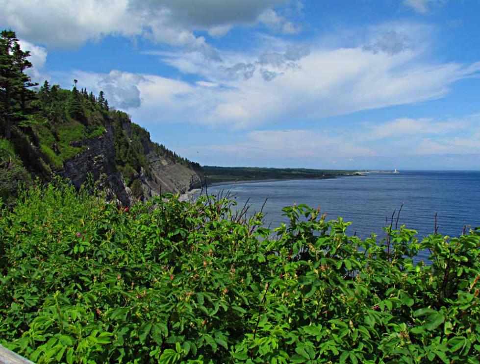
Beautiful Cap Bon-Ami, its cliffs are closer and also have many nesting seabirds as shown in the following.
A stairway to go down to the beach at Cap Bon-Ami.
This is an excellent look-out point for whale watching from shore. We saw several whales from this location
as shown in the following pictures. The most productive time is from June to July when many whales pass
close to shore and can be seen along the shore. A Canadian from Rimouski told us that he saw 60 whales
from this look-out point the night before.
At the right side of this picture, there is a wood handrail of a stairway to go from the park road down to a
lower level lookout area where there is a public high power telescope for visitors on this look-out point to
watch whales in action in Gaspe Bay as shown on the next picture.
This look-out point is located at L'Anse-Aux-AMERINDIENS near the eastern end of the park road along the
southern shore of Forillon National Park.
Map: Click here to see an interactive Google Map showing location of this whale watching look-out point
The entrance trench to see the WWII gun in Forillon National Park.
A waterfall near the stairway.


We toured the Forillon National Park on July 7, 2011. Forillon National Park is located at the extreme northeast
end of the Gaspé peninsula facing the Gulf of St. Lawrence. It is 435 miles (700 km) northeast of Quebec City.
Map: Click here to see interactive Google Map showing location of Forillon National Park
end of the Gaspé peninsula facing the Gulf of St. Lawrence. It is 435 miles (700 km) northeast of Quebec City.
Map: Click here to see interactive Google Map showing location of Forillon National Park

The WWII gun at Fort Peninsule near the southern entrance of Forillon National Park.
During the Second World war, numerous German submarines succeeded in making their way up the St.
Lawrence River and sinking a good number of cargo ships during what is now referred to as the "Battle of the
St. Lawrence". At the start of the Second World War, when Great Britain was under the threat of an invasion,
military authorities went looking on the East Coast of Canada for a port to house the allied fleet in case it was
needed. The Baie de Gaspé’s strategic position and natural characteristics made it the ideal location. Around
the Bay of Gaspe, three forts were established: Fort Prevel, Fort Haldimand and Fort Peninsule. The Port of
Gaspe was chosen as the naval base for the escort ships to protect the convoy of merchant vessels traveling
through this part of Quebec-Sydney route.
Fort Peninsule is located near the southern entrance to the Forillon National Park, and visitors are invited to go
on a self-guided walking tour of the fort. There are many panels around that give information about World War
II in Canada and how these three forts and an anti-submarine net helped protect the Bay of Gaspe.


碧海青天及高峻的海崖,由此瞭望大西洋的遠方, 可以享受到那種無
邊無際,壯闊波瀾的雄偉風景。
Visitors enjoy a spectacular view of the Gulf of St. Lawrence and the soaring cliffs of Cap Gaspé viewed from
Cap Bon-Ami along the north shore of Forillon National Park.
Map: Click here for interactive Google Map showing location of Cap Bon-Ami in Forillon National Park in
Quebec, eastern Canada

意想不到的時候常有驚喜,絕壁攀岩,成千上萬漫天歡舞的白色海
鳥, 這也是觀鳥的樂趣吧。
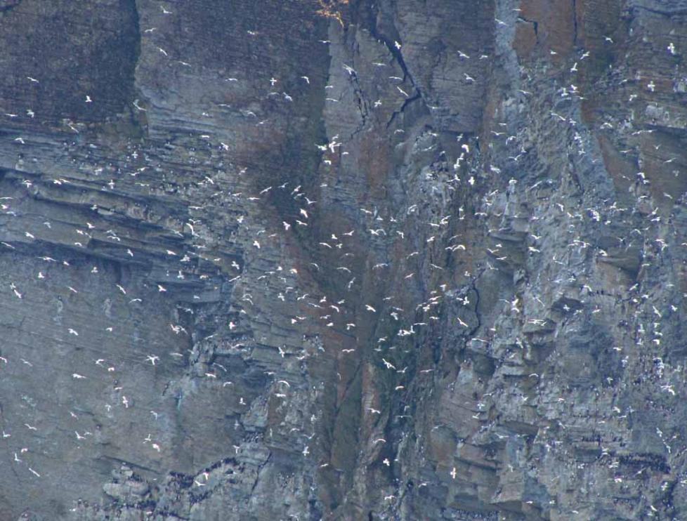
By using the 35X optical zoom of my compact super-zoom camera (Canon PowerShot SX 30 IS) to zoom in,
Wow! the quiet cliffs of Cap Gaspé comes alive with huge number of seabirds flying near those tall cliffs which
are protected bird sanctuary. The park road on north shore ends at Cap Bon-Ami such that Visitors are not
allowed to drive closer to these cliffs of bird sanctuary near Cap Gaspé. (Many pictures taken by regular
cameras from here without super-zoom show only the quiet cliff, but do not show any bird at all.)
I also took a movie clip, by using this super-zoom camera, to show the dynamic flying pattern of the huge
number of seabirds near the rugged cliff of the bird sanctuary of Cap Gaspe in Forillon National Park. The
flights of so many birds are not random, but seem to be following a pattern of group rotation somewhat similar
to the Line-Of-Dance pattern when many people are doing ballroom dancing. Please click on the following
YouTube website to see their group flight pattern:
http://www.youtube.com/watch?v=1HdJSD_pJYE
鳥, 這也是觀鳥的樂趣吧。
By using the 35X optical zoom of my compact super-zoom camera (Canon PowerShot SX 30 IS) to zoom in,
Wow! the quiet cliffs of Cap Gaspé comes alive with huge number of seabirds flying near those tall cliffs which
are protected bird sanctuary. The park road on north shore ends at Cap Bon-Ami such that Visitors are not
allowed to drive closer to these cliffs of bird sanctuary near Cap Gaspé. (Many pictures taken by regular
cameras from here without super-zoom show only the quiet cliff, but do not show any bird at all.)
I also took a movie clip, by using this super-zoom camera, to show the dynamic flying pattern of the huge
number of seabirds near the rugged cliff of the bird sanctuary of Cap Gaspe in Forillon National Park. The
flights of so many birds are not random, but seem to be following a pattern of group rotation somewhat similar
to the Line-Of-Dance pattern when many people are doing ballroom dancing. Please click on the following
YouTube website to see their group flight pattern:
http://www.youtube.com/watch?v=1HdJSD_pJYE

Zoom in for a closer view of the Cap Gaspé, the dramatic, eastern tip of the Appalachian Mountain Range. It
is a place where land and sea collide in a most spectacular way. The hiking trails of the Forillon National Park
are noted for their breathtaking seascapes, especially the path to the lighthouse at the tip of Cap Gaspe.
is a place where land and sea collide in a most spectacular way. The hiking trails of the Forillon National Park
are noted for their breathtaking seascapes, especially the path to the lighthouse at the tip of Cap Gaspe.

By zooming in even more, we see many tiny white dots on the cliff which means that there are huge number of
seabirds nesting on the rugged cliffs in that bird sanctuary. Other black colored seabirds nesting on those cliffs
may not be easily visible at such long distance away.
seabirds nesting on the rugged cliffs in that bird sanctuary. Other black colored seabirds nesting on those cliffs
may not be easily visible at such long distance away.


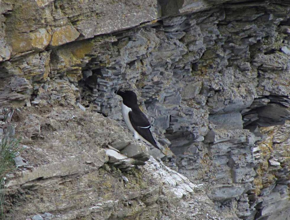
Many Kittiwake and Razorbill (Black colored) nesting on the cliff near Cap Bon-Ami.


There are also many cormorants nesting on the cliff here.
I have seen adult cormorants many times at many places, but this is the first time that I see nests of
cormorants and baby cormorants, especially on a cliff.
I have seen adult cormorants many times at many places, but this is the first time that I see nests of
cormorants and baby cormorants, especially on a cliff.


夏日戀情,自然生態美景,百鳥群舞, 情侶散步的浪漫海灘。
A beautiful pebble beach at Cape Bon Ami at the foot of Mont-St-Alban. With its sheer cliffs plunging
into the sea, pebble beaches lining little coves, and a backdrop of mountains, forests and water,
Forillon is home to spectacular landscapes and a multitude of wildlife species.
A beautiful pebble beach at Cape Bon Ami at the foot of Mont-St-Alban. With its sheer cliffs plunging
into the sea, pebble beaches lining little coves, and a backdrop of mountains, forests and water,
Forillon is home to spectacular landscapes and a multitude of wildlife species.


Several cormorants and other seabirds on a beach in Forillon National Park.


The arching back of a whale surfacing in Gaspé Bay just about hundred yards away that we saw from coastal
look-out point on the shore as shown by the two pictures above.
look-out point on the shore as shown by the two pictures above.

One of several waterspouts from blowholes of whales seen from this lookout point.

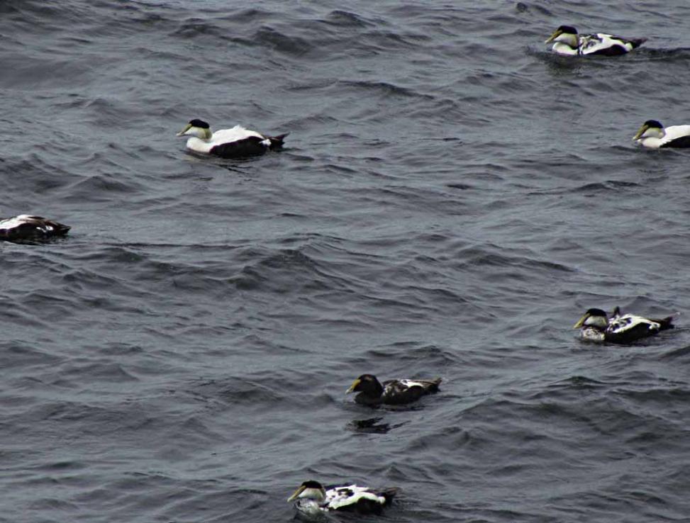
We also saw many seabirds (common eiders and others) from this look-out point.


The Grande-Grave harbour at Grande-Grave in southern coast of Forillon National Park for whale watching
using zodiac, the small rubber boats.
Grande-Grave is thought to come from an old French word describing a pebble beach where salted cod was
sun dried. During the late 19th and early 20th centuries, this is where a large part of the catch was salted,
sun dried and shipped to distant ports in Europe and the West Indies. This is similar to another historical site
of sun dried salted cod at Sainte-Therese-de-Gaspe along Highway 132 about 15 Km south of Perce as
described on my Travelogue web page at:
http://www.shltrip.com/Scenic_Coastal_Highway.html

A whale watching boat running at high speed in Gaspe bay as viewed from the Grande Grave Harbor.
However, we were happy with whale watching from shore at the look-out point described above and did not
get on the whale watching boat here in Forillon National Park.
However, we were happy with whale watching from shore at the look-out point described above and did not
get on the whale watching boat here in Forillon National Park.

Location: Forillon National Park is located at the extreme northeast end of the Gaspé peninsula facing the
Gulf of St. Lawrence. It is 435 miles (700 km) northeast of Quebec City and about 90 Km driving distance
north of the village of Perce and Bonaventure Island.
Map: Click here to see interactive Google Map showing location of Forillon National Park
There are two entrances into Forillon National Park: The North Entrance and the South Entrance.
Direction to Forillon National Park:
From Montreal, take highway 20 going East toward Quebec City along south shore of St. Lawrence River.
Continue on Highway 20 East to Rivière-du-Loup where the road becomes coastal Highway 132 East along
south shore of St. Lawrence River (i.e., north coast of Gaspe Peninsula). Continue on coastal Highway 132
East (On north coast of Gaspe Peninsula) all the way to reach the Forillon National Park.
An Option of South Route: At Ste-Flavie on the north coast of Gaspe Peninsula, Highway 132 splits into (1) a
north route along north coast and (2) a south route crossing the Matapedia Valley to reach the southern
Gaspesie shore. Therefore, there is an option at Ste-Flavie to take the southern Highway 132 along the
Chaleurs Bay on southern coast of Gaspe Peninsula to reach Forillon National Park.
There is yet a third option to come from south through the Province of New Brunswick and to cross the steel
bridge at Campbellton into the Province of Quebec. Then connects into southern coastal Highway 132 to go
east to reach Forillon National Park.
Lodging: For visiting Forillon National Park, the town of Gaspe is about 13 Km south from the southwest
corner of Forillon National Park. There are several motels, restaurants and a supermarket in the town of
Gaspe along Highway 132.
Forillon National Park is a narrow, mountainous peninsula that extends into the Gulf of St. Lawrence and marks
the eastern end of the Appalachian mountain chain. The International Appalachian Trail runs along Gaspe's
Chic-Choc mountains and ends at the light-house on Cap Gaspe in Forillon National Park. The International
Appalachian Trail travels the ancient spine of the Appalachians all the way to Georgia before continuing on to
Florida.
The red colored markings on this detailed park map is the protected bird sanctuary where huge number of
seabirds are nesting on the rugged tall cliffs. Visitors are not allowed to enter the bird sanctuary so that the
bird nesting areas will not be disturbed.
Cap Bon-Ami is at the eastern end of the park road along the north shore of Forillon National Park.
The “Gaspé” is thought to derive from “gespeg,” a First Nations word meaning “land’s end.” The Gaspé
Peninsula will take your breath away with its strikingly beautiful land- and seascapes. The National Geographic
Society has designated Quebec's Gaspe peninsula as the world's third most beautiful destination.
月形的海灣,藍天白雲,高叢的懸崖, 加上碧藍的海水,構成一幅最
美的海岸風情畫。
The Gaspésie peninsula sticks out like a giant tongue into the sea, south of where the Saint-Lawrence River
imperceptibly transforms into a gulf. Situated at one end of the Appalachian Mountains, in the language of the
native Mikma'q people, its name means "land's end." The name still feels right. Winters here are long and
harsh, and the heavy snowfalls often cut Gaspésie off from the rest of Québec, making the warm summer
days that much more precious and liberating for the peninsula's inhabitants. Each year during the brief summer
and fall months, over one million tourists disregard this remoteness and make the journey to Gaspésie,
attracted by its crisp crystalline air and stunning scenery.

The top of the Mont Saint-Alban at Cape Bon Ami has an observation tower located at 283 meters of altitude,
which offers a spectacular 360-degree panorama giving you a view on the river and the gulf, the bay of Gaspe,
Forillon, Gaspe and Perce. It is about 2.2 km of hiking to get up to that vantage point. The comment from a
visitor to that observation tower: "That was one of the best views I have ever seen in my life!"

More photos of large number of seabirds flying near the cliff in this bird sanctuary can be seen on May Lee's
web page at:
http://mayleesart.com/Forillon.html
Forillon is home to a wealth of wildlife and is well-known for its seabirds. When early explorer Samuel de
Champlain first came to the area he wrote, "The abundance of birds of different kinds is so great that no one
would believe it possible unless he had seen it." This spectacle is now limited to the Bonaventure Island and
the protected sheer cliffs near Cap Gaspe in Forillon National Park.
The wide open spaces of the Gaspe Peninsula are a nature lover's dream with exquisite landscapes,
seascapes, boreal forests, and pristine rivers.
seascapes, boreal forests, and pristine rivers.
Part 3 on Mauricie National Park and Saguenay Fjord National Park in the 11-day Tour of Province of Quebec
is at the following web page:
http://www.shltrip.com/Mauricie_NP.html
is at the following web page:
http://www.shltrip.com/Mauricie_NP.html
In 1623, while going through the Gaspe Bay, the missionary Gabriel Sagard described how the continued
roaring noise of the whales and the noise caused by their blowholes was interfering with their sleep. Therefore,
this Look-Out Point in Forillon National Park is an ideal location from the shore to see many whales.
At the upper left corner of this picture, the southern Park Road goes up and reaches its end point. From there,
there is a 4-Km hiking trail where visitors can walk or ride a bicycle to go further east to reach the Cap Gaspe
which is the eastern end of Gaspe Peninsula and the eastern end of the International Appalachian Trail.

The lower level lookout area with a public high-power telescope for whale watching. This picture is taken by
May Lee on the roadside at the higher level Lookout Point as shown on the picture above.
May Lee on the roadside at the higher level Lookout Point as shown on the picture above.
| 讀萬卷書 行萬里路 |

How I use information age technologies to enhance my enjoyment greatly of sightseeing large driving tour
loop of thousands of miles and of one to two weeks in duration covering many Points of Interest is described
on my web page at:
http://www.shltrip.com/Sightseeing_in_Information_Age.html
loop of thousands of miles and of one to two weeks in duration covering many Points of Interest is described
on my web page at:
http://www.shltrip.com/Sightseeing_in_Information_Age.html